


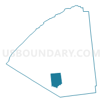
Voting District 090001, St. Lawrence County, New York
About
Outline

Summary
| Unique Area Identifier | 636387 |
| Name | Voting District 090001 |
| County | St. Lawrence County |
| State | New York |
| Area (square miles) | 66.41 |
| Land Area (square miles) | 65.34 |
| Water Area (square miles) | 1.07 |
| % of Land Area | 98.38 |
| % of Water Area | 1.62 |
| Latitude of the Internal Point | 44.23219360 |
| Longtitude of the Internal Point | -75.11135920 |
Maps

Graphs
Select a template below for downloading or customizing gragh for Voting District 090001, St. Lawrence County, New York


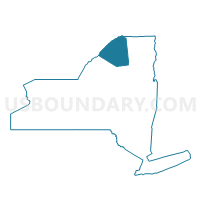
Neighbors
Neighoring Voting District (by Name) Neighboring Voting District on the Map
- Voting District 030001, St. Lawrence County, NY
- Voting District 040001, St. Lawrence County, NY
- Voting District 080001, St. Lawrence County, NY
- Voting District 090002, St. Lawrence County, NY
- Voting District 280001, St. Lawrence County, NY
- Voting District 310002, St. Lawrence County, NY
Top 10 Neighboring County Subdivision (by Population) Neighboring County Subdivision on the Map
- Russell town, St. Lawrence County, NY (1,856)
- Fine town, St. Lawrence County, NY (1,512)
- Edwards town, St. Lawrence County, NY (1,156)
- Pitcairn town, St. Lawrence County, NY (846)
- Clifton town, St. Lawrence County, NY (751)
- Clare town, St. Lawrence County, NY (105)
Top 10 Neighboring Place (by Population) Neighboring Place on the Map
Top 10 Neighboring Unified School District (by Population) Neighboring Unified School District on the Map
- Edwards-Knox Central School District, NY (3,401)
- Harrisville Central School District, NY (2,350)
- Clifton-Fine Central School District, NY (2,257)
Top 10 Neighboring State Legislative District Lower Chamber (by Population) Neighboring State Legislative District Lower Chamber on the Map
Top 10 Neighboring State Legislative District Upper Chamber (by Population) Neighboring State Legislative District Upper Chamber on the Map
Top 10 Neighboring 111th Congressional District (by Population) Neighboring 111th Congressional District on the Map
Top 10 Neighboring Census Tract (by Population) Neighboring Census Tract on the Map
- Census Tract 4926, St. Lawrence County, NY (6,060)
- Census Tract 4925, St. Lawrence County, NY (2,693)
Top 10 Neighboring 5-Digit ZIP Code Tabulation Area (by Population) Neighboring 5-Digit ZIP Code Tabulation Area on the Map
- 13648, NY (2,424)
- 13684, NY (1,131)
- 13635, NY (1,092)
- 13690, NY (846)
- 13670, NY (430)
- 13666, NY (266)
- 13639, NY (243)